
Section 1. Document Status and Scope
This exploratory dossier examines Sant Pere, Santa Caterina i la Ribera (the BASPcr study area). It is not a full scientific study. The analysis is based primarily on public reports and official sources (see source list), which are useful for chronology, administrative change, and planning, but do not provide a complete social record. Gaps remain. The dossier is a first structured assembly of evidence, to be revised and expanded in later phases.
Section 2. Project Motivation and Research Orientation
The neighbourhood was chosen not because it is the smallest possible unit, but because it constitutes a legible intermediate scale between the street and the district. At this scale, historical formation, demographic change, institutional presence, urban morphology, and contemporary social pressures can be studied in relation to one another without losing territorial specificity. Sant Pere, Santa Caterina i la Ribera is especially suited to such a reading because it combines dense historical significance, demographic diversity, architectural and civic concentration, and acute contemporary urban tensions within a relatively bounded environment.
BASPcr begins from a sense of institutional and territorial disconnection. Working as a cultural agent in Sant Pere, Santa Caterina i la Ribera, I experienced the gallery not as part of a shared neighbourhood fabric, but often as an isolated cultural space, weakly connected to its surroundings and to the institutions that shape cultural life in Barcelona. That disconnection also raised a broader concern: the distance between cultural policy and the social realities immediately around us, including inequality, exclusion, and the uneven ways in which recognition and support are distributed. BASPcr emerges from that tension. Its purpose is not only to organize artistic activity, but to ask what a cultural initiative can responsibly be in a neighbourhood marked by long historical pressures and present social contradictions. The project therefore seeks to build a more informed, grounded, and participatory cultural position—one that uses art not as decoration or institutional display, but as a way of engaging the neighbourhood fabric more actively and collectively.
This dossier therefore approaches the neighbourhood through a historical and territorial reading rather than through a single predetermined thesis. Its aim is to establish a grounded preliminary framework from which later phases of research, observation, and intervention can develop.
Section 3. Study Area and Territorial Framing
This dossier takes Sant Pere, Santa Caterina i la Ribera as its primary study area and situates it within the wider district of Ciutat Vella, Barcelona’s historic centre. Ciutat Vella provides the broader historical and territorial context, but it is not the main object of analysis. The focus remains the neighbourhood itself and the processes that have shaped its development.
Ciutat Vella is composed of four neighbourhoods: Barceloneta, El Raval, the Gothic Quarter, and Sant Pere, Santa Caterina i la Ribera. For the purposes of this dossier, the neighbourhood is framed through a working perimeter defined by four main edges: to the northwest, Carrer de Trafalgar and Carrer d’Ortigosa; to the northeast, the line of Carrer de Wellington and the edge of Parc de la Ciutadella; to the southeast, Carrer del Doctor Aiguader and the area of Estació de França; and to the southwest, Via Laietana, the clearest dividing line between this neighbourhood and the Gothic Quarter.
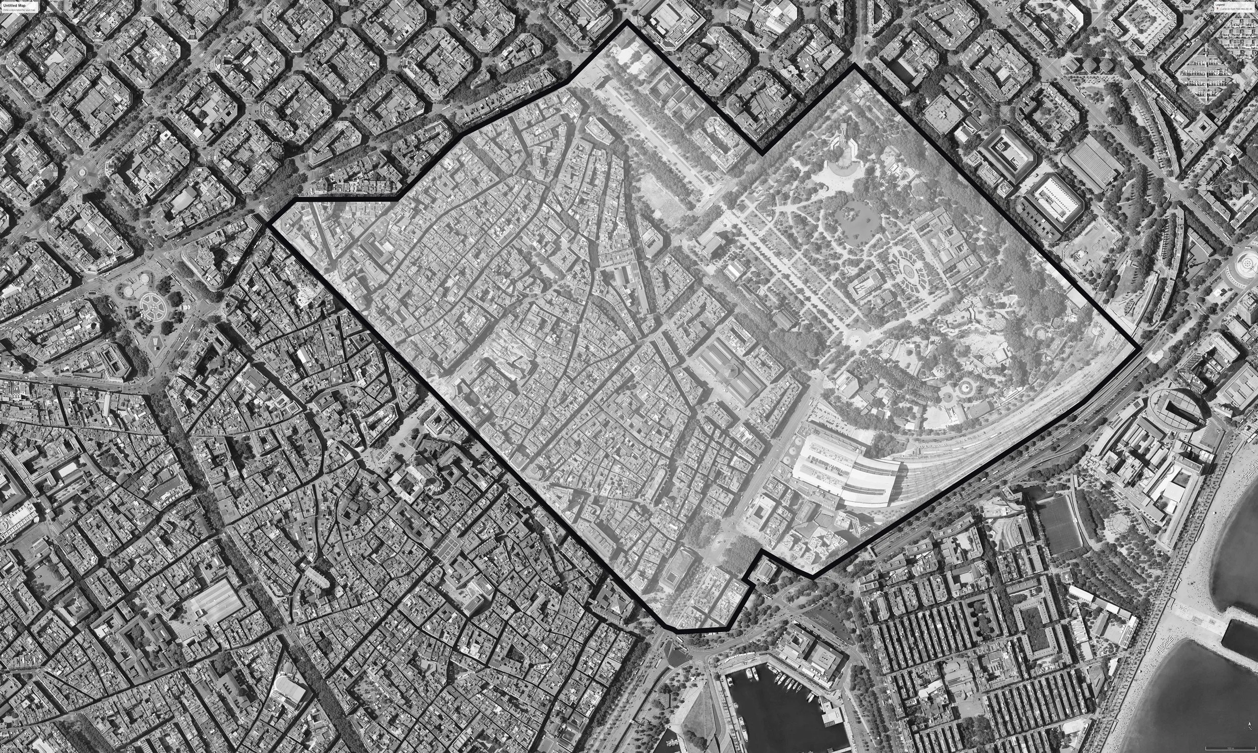
The long name of the neighbourhood reflects its internal historical layering. Sant Pere, Santa Caterina i la Ribera is composed of three historic subareas: Sant Pere, historically associated with the area around the convent of Sant Pere de les Puel·les; Santa Caterina, linked to the former convent of Santa Caterina and the area later occupied by the market; and La Ribera, associated with the zone around Santa Maria del Mar.
Within this structure, “El Born” should be treated only as a partial and colloquially dominant name, mainly associated with part of La Ribera, and not as a substitute for the neighbourhood as a whole.
Section 4. Historical Development of the Neighbourhood
Before 1000 CE
Before Barcelona emerged as a Roman city, the surrounding coastal plain was already inhabited by indigenous populations, mainly the Laietani. The historic urban core of the city began when the Romans founded the colony of Barcino on Mont Tàber between 15 and 13 BC. This origin should not be understood as the beginning of settlement in an empty space, but as the establishment of a colonial urban nucleus within an already occupied territory. The city’s formal Roman name was Colonia Iulia Augusta Faventia Paterna Barcino, in which “Barcino” was the place-name and the preceding words were imperial and honorific titles. (Meet Barcelona)
During the first centuries of the Roman period, Barcino developed as a compact enclosed settlement. A first wall was built between the 1st and 2nd centuries AD, fixing the early perimeter of the urban core. By the late 3rd and 4th centuries, and especially around 260 AD, that enclosure had been reinforced into a much stronger defensive system with towers. This fortified perimeter remained structurally decisive long after the Roman period itself and continued to shape the city well into the Middle Ages. At the centre of the Roman city stood the forum, which concentrated its main civic, political, religious, and commercial functions. Near that centre, on Mont Tàber, stood the Temple of Augustus, built in the 1st century BC and dedicated to the worship of Emperor Augustus, linking religion directly to Roman political power. (Meet Barcelona)
By the 5th and 6th centuries, the city had entered a different political and urban phase. The Roman forum no longer functioned as the central civic and religious core of the city, and the Temple of Augustus had lost its original role. At the same time, Christian institutions became increasingly important in the reorganization of urban life. Archaeological and cathedral history sources indicate the existence of a paleo-Christian basilica from the 4th century and later an episcopal complex, showing that the religious centre of the city had shifted away from the old Roman civic cult. The internal street fabric had narrowed and subdivided, and Barcelona had become part of the Visigothic world, at moments even serving as a seat of power. The city’s name also began to evolve during this broader late antique and medieval transition: the Roman form Barcino did not change to Barcelona in a single year, but gradually passed through later forms such as Barcinona before stabilizing in later centuries. (Barcelona Cathedral)
Despite these internal transformations, the city remained concentrated within the inherited Roman enclosure. The relative stability of its outward form before the year 1000 should therefore not be read as historical inactivity, but as a period in which political, religious, and social changes took place within a still compact fortified core. By around 1000, after the raid of Al-Mansur in 985, the city entered a renewed phase of activation linked to the surrounding countryside, while still remaining relatively compact and enclosed. (Meet Barcelona)
Sources used for this section: Barcelona City Council, “Roman Barcino”; Cultural Heritage of Catalonia, “Barcino”; MUHBA historical cartography provided in this conversation; MUHBA Temple d’August / Barcelona Turisme institutional page; Barcelona Cathedral history. (Meet Barcelona)
From 1000 CE onward
From the 11th century onward, Barcelona began to grow beyond the old Roman core. During this period, the Rec Comtal became a key water infrastructure for the city and the surrounding plain, supplying water for irrigation, mills, and other productive activities. This was especially important on the eastern side of the city, where early growth outside the walls developed around religious centres, routes of access, and the water system itself. These processes were central to the later formation of Sant Pere, Santa Caterina and La Ribera.
By the late 13th and 14th centuries, a new medieval wall incorporated many of these outer areas into a larger urban perimeter. This changed the city not only defensively but territorially, turning earlier settlements outside the walls into parts of a broader urban whole. The old Roman wall remained inside the expanded city as an internal line. This new perimeter also enclosed the western area that would later be known as El Raval, while on the eastern side the enlarged city grew around the combined influence of religious institutions, water infrastructure, and later commercial activity.
Between the late 15th and 17th centuries, the maritime front, the port, and the coastal edge became increasingly important in the city’s configuration because Barcelona’s commercial and maritime functions required new works along the waterfront. The first artificial port works began in 1477 and continued through the following centuries, while the maritime façade was progressively consolidated after 1535. At the same time, convent expansion, commerce, and military pressures continued to transform the old city. The Catalan Revolt, beginning in 1640, formed part of a wider conflict in which the Spanish and French monarchies were at war and Castilian troops were stationed in Catalonia, generating severe tensions in the territory. By the mid-17th century, war and militarization had again reshaped the city. At the end of the century, Barcelona was also marked by the Nine Years’ War of 1688–1697, including a siege and bombardment that affected in part the Ribera sector.
The defeat of Barcelona in 1714 marked a major political and urban turning point for La Ribera and the eastern sector of the old city. After the Bourbon victory and the Nueva Planta decrees of 1716, Catalan institutions were abolished and a more centralized political order was imposed. For this area, the most direct consequence was the demolition of part of La Ribera to clear space for the Ciutadella fortress, built to control the city after the war. This reorganization also appears to have altered the water line running through the eastern sector. Archaeological evidence places one of its post-war diversions at Plaça de Pons i Clerch, linking the change directly to the destruction of part of La Ribera after the War of the Spanish Succession. The creation of Barceloneta in 1753 formed part of this same reorganization of the eastern waterfront and responded in part to the displacement caused by the destruction of the Ribera neighbourhood.
By the mid-18th century (c. 1750), the area of Sant Pere already had a strong concentration of indianas factories, that is, workshops and manufactories dedicated to printed cotton textiles. This matters because the indianas industry had begun in Barcelona earlier in the century and became one of the key forces in the city’s commercial and industrial transformation. In Indianes, 1736–1847. Els orígens de la Barcelona industrial, Jaume Artigues and Francesc Mas state that the first manufacturing concentration formed initially around Sant Pere, where the proximity of Portal Nou, the Rec Comtal, the bleaching grounds of Sant Martí, and the concentration of textile artisans favoured the installation of early indianas workshops and factories. Many of these establishments took the form of casa-fàbrica buildings, a mixed type that combined dwelling and production and helped reshape the dense fabric of the neighbourhood. The same publication also shows that the Raval later became important for larger manufacturing establishments because it offered more space than the already dense fabric of Sant Pere.
In the first half of the 19th century (c. 1800–1850), Barcelona remained a dense walled city, but the surrounding plain was already being transformed by productive activity, industrial growth, and more intensive use of the territory. By the 1830s and 1840s, pressure inside the walls had become severe, while the burning of convents and the seizure of church property opened new spaces for squares, markets, and new construction. In this context, the Mercat de Santa Caterina was built on the site of the former convent and inaugurated in 1848, becoming the first covered market in Barcelona. This gave Santa Caterina a new civic and commercial centre at a moment when the old city was becoming more crowded, more industrial, and more strained within its historic enclosure.
In the second half of the 19th century (c. 1850–1900), Barcelona underwent one of the most decisive transformations in its urban history. In 1859, the state approved the Reform and Expansion Plan of Ildefons Cerdà, which proposed the extension of the city across the plain and the reform of the old urban fabric. Together with the demolition of the city walls, this marked the end of the old walled city and opened the way for large-scale growth through the Eixample. At the same time, the former Ciutadella military complex began to lose its defensive role: after the transfer of its lands to the city in 1869, the area was gradually transformed into what became the Ciutadella Park, whose importance was consolidated with the 1888 World’s Fair. The Arc de Triomf, erected in the same year as the main entrance to the Exposition, formed part of this same reconfiguration of the eastern side of the city. The neighbourhood no longer formed part of a compact enclosed city, but became part of the historic core within a much larger Barcelona. By the end of the century, the city was expanding rapidly beyond its former limits, while older sectors within the former walled perimeter, including the Raval, appeared much more fully built up and consolidated.
In the early 20th century (c. 1900–1936), Barcelona became much denser and more populous through industrial growth, immigration, and major urban works. Between 1900 and 1930, the city grew from around half a million to one million inhabitants. New infrastructures and interventions, including the first metro line in 1924 and the 1929 International Exposition, further transformed the city. In the neighbourhood, the opening of Via Laietana became one of the most consequential changes of the period, which restructured the eastern side of Ciutat Vella and linked the Eixample more directly with the port and Estació de França. This was also the period in which the Palau de la Música Catalana was built (1905–1908), reinforcing the neighbourhood’s cultural significance within the expanding city. At the same time, this rapid growth took place under conditions of strong social inequality, which also led to the extension of substandard housing and shantytowns in the wider city.
From the 1950s to the beginning of the democratic period (c. 1950–1976), Barcelona entered a new phase of growth marked by dictatorship, postwar scarcity, and later technocratic planning. In 1953, the opening of the SEAT factory in the Zona Franca and the approval of the Pla Comarcal marked a new phase of growth in which planning was no longer focused only on Barcelona itself, but on the wider metropolitan area. Large new housing estates were built mainly outside the old centre in response to severe housing shortages and intense migratory growth. While Barcelona expanded outward in other areas, Sant Pere, Santa Caterina i la Ribera faced a different process: overcrowding, building deterioration, poor sanitary conditions, and long-running planning uncertainty within the existing historic fabric. Ajuntament de Barcelona planning and district documents indicate that, from the 1950s onward, some sectors of Ciutat Vella lost population under poor living conditions, while densities remained very high and the street network extremely weak and narrow (Ajuntament de Barcelona / BCNROC, Level A). In Santa Caterina and Sant Pere in particular, public authorities planned major street openings such as García Morato, Méndez Núñez, and Francesc Cambó, but these plans remained in place for many years. That long uncertainty discouraged investment, since owners had little reason to repair or improve buildings that might later be altered or demolished. As a result, housing deterioration became a central problem: many buildings were old, many dwellings had been subdivided into very small units, and basic sanitary conditions were often poor.
From the democratic transition to Olympic Barcelona (c. 1976–1992), Barcelona moved into a new phase of metropolitan planning. The approval of the Pla General Metropolità in 1976 marked the main break with the previous period. In Ciutat Vella, this shift later took shape through the PERI del Sector Oriental in 1986 and, from 1988 onward, through new rehabilitation bodies such as the Oficina de Rehabilitació de Ciutat Vella and Procivesa. In Sant Pere, Santa Caterina i la Ribera, the focus turned toward rehabilitation, housing improvement, and more direct forms of urban management. Meanwhile, the city as a whole was being prepared for the metropolitan transformation associated with the 1992 Olympic cycle.
From Olympic Barcelona to the early 2000s (c. 1992–2004), intervention in Santa Caterina and Sant Pere became more concrete and localized, but it also unfolded within a wider phase of eastward redevelopment across Barcelona. After the economic crisis of the mid-1990s, major urban projects reshaped areas such as inner Poblenou, Diagonal Mar, La Mina, the Fòrum, and the 22@ district, while the extension of Diagonal to the sea reinforced this new orientation of urban investment. In Santa Caterina and Sant Pere, the most visible changes were the remodelling of the Mercat de Santa Caterina, the transformation of the Porta Cambó area, and the reurbanization of Avinguda Francesc Cambó. Municipal documents connect these works to broader efforts to improve access, public space, commercial activity, and urban services around the market. By 2004, this process was reinforced through the Llei de Barris framework for Santa Caterina and Sant Pere, which linked neighbourhood renewal to building rehabilitation, new facilities, and social and economic recovery. At the same time, official historical accounts of the city also stress that this broader phase of renewal generated strong public controversy, as urban transformation, economic promotion, and social cohesion did not fit together easily. (MUHBA / Ajuntament de Barcelona, Level A)
By 2010, the largest new urban operations in Barcelona were concentrated further east, from Plaça de les Glòries toward the Besòs, Sagrera, and Sant Andreu. In Sant Pere, Santa Caterina i la Ribera, however, the more important story was the implementation of the neighbourhood-scale interventions set in motion in the previous period. Under the Llei de Barris framework, works advanced at Pou de la Figuera, including the urbanization of public space, new leisure and sports areas, and a support facility at Sant Pere Més Baix 70–74; another civic-use facility was planned at Carders 33–37. Around the same time, municipal records show the extension of the community programme “Puja’m-baixa’m” to Santa Caterina and Sant Pere, aimed at reducing the isolation of older residents. By the end of the decade, Ciutat Vella was also increasingly being governed through the lens of tourism, which the Barcelona Strategic Tourism Plan already described as especially intense in the district.